Viewing well, field, pool, and spacing attributes
Viewing spacing attributes
Using the Map toolbar to the right of the map window, select the type of information for which to view details (wells (
![]() ), fields (
), fields (
![]() ), pools (
), pools (
![]() ), applied-for (
), applied-for (
![]() ), and approved (
), and approved (
![]() ) well spacing), and then click the desired item or location on the map.
) well spacing), and then click the desired item or location on the map.
Information about that item appears in an attribute table below the map. For details on displaying well, field, pool, and other layers, see Using the Layers tab.
The attribute table provides comprehensive information on selected spacing as follows:
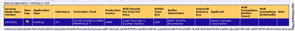
A holding/unit attribute table.
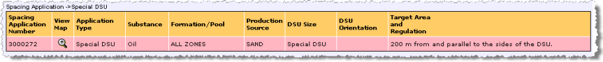
A special DSU attribute table.
To view well information
View well information (location, name, licence number, and bottom hole location), and production string attributes (producing pool, UWI, well status, and confidentiality).
Producing pools aren't displayed for confidential wells.
- Using the Map toolbar to the right of the map, click Show Well Information (
 ).
).
- Do either of the following:
- To display attributes for a single well, with the Well layer selected in the Layers tab so that wells appear on the map, click directly on the well symbol on the map.
- To display attributes for multiple wells, drag your cursor to define an area within which to display attributes for all wells.
The attribute table for the well(s) selected above appears below the map. All event sequences are listed in the attribute table.
- Using the attributes table, click the UWI colored blue to highlight the well on the map with a red star (
 ).
).
The well is denoted on the map with a red star and the corresponding row is highlighted yellow in the attribute table.
To view field information
- Using the Map toolbar to the right of the map, click Show Field Information (
 ).
).
- Do either of the following:
- To display attributes for a single field click the map in the area of interest.
- To display attributes for multiple fields, drag your cursor to define an area within which to display attributes for all fields.
The area you select must be no more than 100 townships and must contain or overlap an active field.
The attribute table for the field(s) selected above appears below the map.
- Using the attributes table, click the field ID colored blue to redraw the map centred on the field at a scale appropriate to view its extents.
- Either click another field in the attribute table below the map, or click Back to Last Extent (
 ).
).
To view pool information
- Using the Map toolbar to the right of the map, click Show Pool Information (
 ).
).
- Do either of the following:
- To display attributes for a single pool click the map in the area of interest.
- To display attributes for multiple pools, drag your cursor to define an area within which to display attributes for all pools.
The area you select must be no more than nine townships and must contain or overlap an active pool.
The attribute table for the pool(s) selected above appears below the map.
- Using the attributes table, click the pool ID colored blue to redraw the map centred on the pool at a scale appropriate to view its extents.
- Either click another pool in the attribute table below the map, or click Back to Last Extent (
).
To view applied-for spacing information
- Using the Map toolbar to the right of the map, click Show Applied-for Spacing Information (
 ).
).
- Click the desired applied-for spacing area on the map.
The attribute table for the applied-for spacing selected above appears below the map.
- Using the attributes table, click
 in the desired row to highlight the applied-for spacing on the map. Click a second time to clear highlighting on the map, or click in a different row in the attribute table to highlight a different spacing.
The map scale doesn't change, so the full extents of the spacing you clicked above may not be visible.
- To zoom to the extents of the applied-for spacing, click Zoom to highlighted spacing (
 ) on the Map toolbar to the right of the map.
The map redraws at a scale at which the full extents of the applied-for spacing appear.
Wells included in the selected application are depicted on the map surrounded by a triangle (
![]() - production data), a circle (
- production data), a circle (
![]() -volumetric data), or both (
-volumetric data), or both (
![]() ). If the application is to rescind a either holding, area, full or partial unit, or approved well spacing, red dots (
). If the application is to rescind a either holding, area, full or partial unit, or approved well spacing, red dots (
![]() ) fill the affected area.
) fill the affected area.
To view approved spacing information
- Using the Map toolbar to the right of the map, click Show Approved Spacing Information (
 ).
).
- Click the desired approved spacing on the map.
The attribute table for the approved spacing selected above appears below the map.
- Click
in the attributes table to highlight the approved spacing on the map. Click
for multiple spacing applications to highlight multiple areas on the map. Click
a second time to clear the highlighting for a spacing from the map.
The map scale doesn't change, so the full extents of the spacing you clicked above may not be visible.
- To zoom to the extents of the approved spacing, click Zoom to highlighted spacing () on the Map toolbar to the right of the map. The map redraws at a scale at which the full extents of all of the items selected in the attributes table appear. If multiple rows with widely spaced items are selected in the attributes table, the map scale may be too large.
Approved applications aren't visible on the Well Spacing Map until the day after they're approved.