Well Spacing User Guide
A Users Guide
Change Management Reference Number
09-169
![]()
Table of Contents
1.0 About the Well Spacing Map
2.0 Narrowing the map focus
2.1 Narrowing spacing attributes
2.2 Using the Layers tab
3.0 Viewing spacing attributes
3.1 Printing the map
4.0 Submitting, changing, and rescinding applications
5.0 Screen Descriptions
1.0 About the Well Spacing Map
The Well Spacing Map is an interactive mapping application that shows all the Approved and the Applied-For well spacing in the province of Alberta. It enables you to display provisions for specific spacing. Standard well spacing allowances are described in AER Directive 065.
The Well Spacing Map can be launched from the main ERCB website (using the Quick Links drop-down list on the right side of the web page), from the ERCB's Digital Data Submission (DDS) system, or while completing an online Spacing form using the ERCB Electronic Application System (EAS).
Well Spacing Map features include the following:
- Query functionality to automatically display an area and spacing provisions using the application number.
- Options to narrow your geographic focus using either query criteria or map navigation tools.
- Tools that provide full map control including zooming, panning, and feature highlighting.
- Color coded tables that appear below the map that list detailed spacing provisions and from which you can select the item to highlight on the map.
- Complimentary functionality with the EAS system so that using the Well Spacing Map, you select the area of interest to automatically include with your EAS application.
The below figure illustrates many of the features of the Well Spacing Map.

The Well Spacing Map appears in the centre above with some of the features highlighted around the outside.
The Well Spacing Map uses colour to highlight well spacing. Each spacing approval is a unique color on the map. The colors on the map match the colors of each spacing approval that appears in the attribute table below the map. Where overlapping spacing approvals appear on the map, the colors on the map meld so that the colors in the attribute table may not match the colors on the map. Narrow your search to a specific formation, field, substance, or spacing type to reduce this effect.
Following are the four main tabs, which enable you to navigate to an area, configure the map display, and populate an online spacing application that's completed using the ERCB EAS system.

2.0 Narrowing the map focus
The Navigation tab enables you tolocate a specific spacing application by application number, or to narrow your map based on geographic area, substance, spacing type, production source, or formation.
Click Show Overview (![]() ) in the map toolbar at any time to display a thumbnail map in the top-left corner of the map that highlights your current map extents. As your extents change on the main map, they also change in the thumbnail map. Return to previous map windows by clicking Back to Last Extent (
) in the map toolbar at any time to display a thumbnail map in the top-left corner of the map that highlights your current map extents. As your extents change on the main map, they also change in the thumbnail map. Return to previous map windows by clicking Back to Last Extent (![]() ) in the Map toolbar.
) in the Map toolbar.
To zoom in on an area
Draw a rectangle around the desired area, or click the map with either of the zoom tools (
![]() ) selected to change the current map scale by 50%.
) selected to change the current map scale by 50%.
- Click the Zoom In tool () in the map toolbar.
- Using your mouse, point to one corner of the desired area on your map.
- Drag your mouse to the opposite corner of the desired area.
The map redraws to display only the area you outlined.

To search using an application number
Centre the map using an application number for an Approved or Applied-For spacing. To instead focus the map on an area based on substance, spacing type, production source, or formation, see Narrowing spacing attributes.
- Type the application number in the Application Number field in either the Search by Applied-For Spacing pane, or in the Search by Approved Spacing pane.
You must type the exact application number in this field. Wildcards aren't supported.

- Click Search next to the field in which you typed the application number.
The map is redrawn at a scale of 1:150,000 with either the Applied-For or the Approved application highlighted and centered on the map. To rescale the map so that the extents of the special spacing are visible, click Zoom to highlighted spacing (![]() ) in the Map toolbar.
) in the Map toolbar.
- View the details of well spacing listed in the attributes table below the map, or continue to zoom in using the Zoom In tool ().
The desired application may not appear if one of the following conditions apply:
- The application was approved before the initial release of the Well Spacing Map (October 27, 2007).
- The application number you typed isn't valid.
- The application was superseded by a more recent application to amend the spacing.
- The application was used to rescind special spacing.
- A day hasn't passed since the application was initially applied-for or approved.
To search using DLS coordinates
Narrow the focus of your map using the dominion land survey coordinates from your area of interest. Optionally, see To search using a UWI below.
- Using the Search by DLS area, type the coordinates within the province of Alberta for your area of interest.

You must specify at least the Township (TWP), Range (RGE),
and Meridian (MER).
- Click Search next to the Search by DLS field.
The map redraws to display your area of interest and a few of the surrounding parcels. Your area of interest is highlighted using red cross-hatching. When you change the current map view (by changing the scale, map centre, etc.), the red cross-hatching disappears.
If you've only defined the mandatory DLS fields above, special spacing may not be visible at the current map scale. Either include section and township numbers in the DLS fields above, or using the Zoom In tool () drag a smaller area on the map, or click the centre of your area of interest.
To search using a field name
Use the name of a field to narrow the focus of your map. The extents of fields and pools are imported from the Board Order System (BOS). If the extents appear to be out of date, it's possible that recent changes to the BOS haven't been imported yet due to the limited time available between the BOS approval and the Well Spacing Map update. The import process usually takes 48-hours.
- Using the Search by Field drop-down list, select the desired field.

Strike areas aren't included in the drop-down list. Should your area of interest fall outside of a defined field boundary, use other navigation methods. For example,
search using DLS coordinates.
- Click Search next to the Search by Field drop-down list.
The map redraws to display the extents of the field plus a few of the surrounding parcels. The desired field is highlighted using red cross-hatching. When you change the current map view (by changing the scale, map centre, etc.), the red cross-hatching disappears.
If special spacing isn't visible at the current map scale, using the Zoom In tool () either drag a smaller area on the map, or click the centre of your area of interest.
To search using a UWI
Type a unique well identifier upon which to centre your map. If you don't know the complete UWI for the desired well, see To search using DLS coordinates above, which enables you to search using meridian, range, and township.
- Type a UWI in the Search by Well UWI field.

Type a full UWI and use the slashes and dashes as indicated above. Wildcards can't be used.
- Click Search next to the Search by Well UWI field.
The map redraws at a scale of 1:18,900 and the desired well is centered on the map and denoted with a red star (![]() ), regardless of whether the Well layer (
), regardless of whether the Well layer (![]() ) is selected in the Layers tab.
) is selected in the Layers tab.
To search using a municipality name
Select the name of a municipality with which to narrow the focus of your map.
- Using the Search by Municipality drop-down list, select the name of the desired municipality.
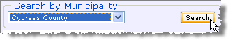
In this example, the municipal district of Cypress County is selected.
- Click Search next to the Search by Municipality field.
The map redraws to display the municipality plus a few of the surrounding parcels. The municipality is centred on the map and highlighted using red cross-hatching. When you change the current map view (by changing the scale, map centre, etc.), the red cross-hatching disappears.
If special spacing isn't visible at the current map scale, using the Zoom In tool () either drag a smaller area on the map, or click the centre of your area of interest.
2.1 Narrowing spacing attributes
Once you've reduced your map extents to an area of interest by Narrowing the map focus, your next step is to view approved and applied-for spacing within those extents.
It's a good idea to enable the Development Entity Areas layer using the Layers tab of the Well Spacing map. If your desired area falls within one of the development entity areas, the standard well density is automatically increased and you may not need to complete a well spacing application. See AER Directive 065 for details.
To narrow spacing attributes
- Using the Navigation tab, in either the Find Approved Spacing, or Find Applied-For Spacing pane, select from the following options:
- The substance being produced.
- The spacing type.
- The source of production.
- One or more formations. Using the Formation drop-down list, select the name of the desired formation. Either click the desired name, or hover your cursor over it so that it's highlighted and then press Enter.
To remove an item from the list of selected formations, select it and then click .
You can also select All Formations or All Zones.
.
You can also select All Formations or All Zones.
- Click Search at the bottom of either the Find Approved Spacing or the Find Applied-For Spacing pane, depending on which pane you used to select the desired criteria.

The example criteria above retrieves approved spacing for Holdings for both oil and gas that are producing from Sand in either the Cooking Lake or the Leduc formations.
An attribute table with spacing that matches the criteria defined above and that's within your current map extents appears below the map.
- Using the attributes table, click
 in the desired row to highlight the Approved or Applied-For spacing on the map. Click a second time to clear highlighting on the map.
Clicking in a row when spacing is already highlighted for a different row causes the map to behave differently depending on whether the attribute table displays Approved or Applied-For spacing. For Approved spacing, the map highlights all the selections on the map that you click in the attribute table. For Applied-For spacing, the map clears the previous selection and only displays the selection you just clicked.
The map scale doesn't change, so the full extents of the spacing you clicked above may not be visible.
- To zoom to the extents of the spacing, click Zoom to highlighted spacing (
 ) on the Map toolbar to the right of the map. The map redraws at a scale at which the full extents of the spacing appear.
Formation searches are very specific
Searching by formation is specific to the formation(s) selected. For example, if you select the EDMONTON GRP, you see spacing that applies to the entire Edmonton Group, not spacing that applies to only the Lower Edmonton or the Upper Edmonton.
We recommended you begin your investigation of the spacing within an area by selecting the All Formations option from the Formation drop-down list. Once you have a feel for the area, you can focus your search on specific formations.
When you search using All Formations, pools also appear in the attribute table in the Formation/Pool column following the name of the formation to which they pertain.
2.2 Using the Layers tab
The Layers tab provides controls to select the map features to display on the map.
Related map features are grouped into layers. To avoid over-posting, each map layer has a maximum map scale at which it displays. For details on displaying the attributes of wells, fields, pools, and spacing, see Viewing spacing attributes.
To show or hide layers
- Select or clear the check box to the left of the layer name.
- Click Refresh Map below the list of map layers.
The map redraws to include only the selected layers.
The map layers selected appear on the map when you are at the appropriate map scale. For example, roads and lakes start to appear at a scale of 1:160,000.
3.0 Viewing spacing attributes
Using the Map toolbar to the right of the map window, select the type of information for which to view details (wells (
![]() ), fields (
), fields (
![]() ), pools (
), pools (
![]() ), applied-for (
), applied-for (
![]() ), and approved (
), and approved (
![]() ) well spacing), and then click the desired item or location on the map.
) well spacing), and then click the desired item or location on the map.
Information about that item appears in an attribute table below the map. For details on displaying well, field, pool, and other layers, see Using the Layers tab.
The attribute table provides comprehensive information on selected spacing as follows:
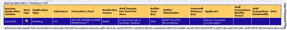
A holding/unit attribute table.
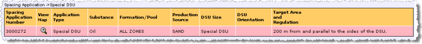
A special DSU attribute table.
To view well information
View well information (location, name, licence number, and bottom hole location), and production string attributes (producing pool, UWI, well status, and confidentiality).
Producing pools aren't displayed for confidential wells.
- Using the Map toolbar to the right of the map, click Show Well Information (
 ).
).
- Do either of the following:
- To display attributes for a single well, with the Well layer selected in the Layers tab so that wells appear on the map, click directly on the well symbol on the map.
- To display attributes for multiple wells, drag your cursor to define an area within which to display attributes for all wells.
The attribute table for the well(s) selected above appears below the map. All event sequences are listed in the attribute table.
- Using the attributes table, click the UWI colored blue to highlight the well on the map with a red star (
 ).
).
The well is denoted on the map with a red star and the corresponding row is highlighted yellow in the attribute table.
To view field information
- Using the Map toolbar to the right of the map, click Show Field Information (
 ).
).
- Do either of the following:
- To display attributes for a single field click the map in the area of interest.
- To display attributes for multiple fields, drag your cursor to define an area within which to display attributes for all fields.
The area you select must be no more than 100 townships and must contain or overlap an active field.
The attribute table for the field(s) selected above appears below the map.
- Using the attributes table, click the field ID colored blue to redraw the map centred on the field at a scale appropriate to view its extents.
- Either click another field in the attribute table below the map, or click Back to Last Extent (
 ).
).
To view pool information
- Using the Map toolbar to the right of the map, click Show Pool Information (
 ).
).
- Do either of the following:
- To display attributes for a single pool click the map in the area of interest.
- To display attributes for multiple pools, drag your cursor to define an area within which to display attributes for all pools.
The area you select must be no more than nine townships and must contain or overlap an active pool.
The attribute table for the pool(s) selected above appears below the map.
- Using the attributes table, click the pool ID colored blue to redraw the map centred on the pool at a scale appropriate to view its extents.
- Either click another pool in the attribute table below the map, or click Back to Last Extent (
).
To view applied-for spacing information
- Using the Map toolbar to the right of the map, click Show Applied-for Spacing Information (
 ).
).
- Click the desired applied-for spacing area on the map.
The attribute table for the applied-for spacing selected above appears below the map.
- Using the attributes table, click in the desired row to highlight the applied-for spacing on the map. Click a second time to clear highlighting on the map, or click in a different row in the attribute table to highlight a different spacing.
The map scale doesn't change, so the full extents of the spacing you clicked above may not be visible.
- To zoom to the extents of the applied-for spacing, click Zoom to highlighted spacing () on the Map toolbar to the right of the map.
The map redraws at a scale at which the full extents of the applied-for spacing appear.
Wells included in the selected application are depicted on the map surrounded by a triangle (
![]() - production data), a circle (
- production data), a circle (
![]() -volumetric data), or both (
-volumetric data), or both (
![]() ). If the application is to rescind a either holding, area, full or partial unit, or approved well spacing, red dots (
). If the application is to rescind a either holding, area, full or partial unit, or approved well spacing, red dots (
![]() ) fill the affected area.
) fill the affected area.
To view approved spacing information
- Using the Map toolbar to the right of the map, click Show Approved Spacing Information (
 ).
).
- Click the desired approved spacing on the map.
The attribute table for the approved spacing selected above appears below the map.
- Click
in the attributes table to highlight the approved spacing on the map. Click
for multiple spacing applications to highlight multiple areas on the map. Click
a second time to clear the highlighting for a spacing from the map.
The map scale doesn't change, so the full extents of the spacing you clicked above may not be visible.
- To zoom to the extents of the approved spacing, click Zoom to highlighted spacing () on the Map toolbar to the right of the map. The map redraws at a scale at which the full extents of all of the items selected in the attributes table appear. If multiple rows with widely spaced items are selected in the attributes table, the map scale may be too large.
Approved applications aren't visible on the Well Spacing Map until the day after they're approved.
3.1 Printing the map
Print the Spacing Map using your Browser's print capabilities.
Here are some tips on how to produce an effective printout:
- Print the Spacing Map in Landscape orientation. The map and attribute tables are designed to fit your screen when the display is wider than it is tall. This command is available from the File menu using the Page Setup command.
- Print just the attribute table by right-clicking the attribute table and clicking Print from the shortcut menu.
- Print tables on legal sized paper. The attribute tables are often wider than what fits on 11-inch paper.
4.0 Submitting, changing, and rescinding applications
Use this process to do the following:
- Submit a new well spacing application.
- Rescind approved spacing.
- Modify spacing.
After you review spacing attributes in an area of interest, launch the ERCB's Digital Data Submission (DDS) system to complete an online spacing application using the ERCB Electronic Application System (EAS). Using the EAS form, select an application purpose of New Spacing, Rescind Spacing, or Modify Spacing. For criteria around submitting spacing applications, see AER Directive 065.
While completing the form, a View Map button on the EAS form enables you to launch the Well Spacing Map. Use the Spacing Application tab of the Well Spacing Map to click areas on the map to add to your EAS application. These details are automatically added to your EAS application.

The Spacing Application tab is only available when you launch the Well Spacing Map using the EAS form.
To submit spacing applications
- Launch the DDS website, log on, and then select ERCB > Applications > Facilities/Resources Application > Submit Resources Application.
- Complete Resources Applications - Schedule 1 selecting an Application Type of either Spacing: Gas or Spacing: Oil and an Application Purpose of Modify Spacing, New Spacing, or Rescind Spacing.
- Click Go To Form and start the Directive 065 Spacing Application form.
Help is available from EAS by clicking the Help button in each section of various forms.

- In Section 3 Area of Application of the EAS form, click View Map as depicted below.

The Well Spacing Map launches.
- Either using the Navigation tab or the toolbar buttons, navigate to an area of interest.
Your map must be at a scale of 1:150,000. For details on navigating the Well Spacing Map, see Narrowing the map focus.
Note: It's a good idea to enable the Schedule 13A and 13B layer using the Layers tab of the Well Spacing map. If your desired area falls within one of the development entity areas, the standard well density is automatically increased and you may not need to complete a well spacing application. See AER Directive 065 for details.
- Click the Spacing Application tab.
- Complete the numbered steps on the Spacing Application tab as follows:
- Step 1 - Use the Navigation tab to narrow the map window to a distance of two townships by two ranges. See Narrowing the map focus for details.
- Step 2 - Select the Start Spacing Application check box to disable the Well Spacing map toolbar while you specify details to automatically add to your EAS Spacing application. You can't navigate the map and populate the EAS form at the same time.
The map is redrawn at a scale of 1:150,000.
Tip: To enable buttons in the map toolbar, click Enable Map Toolbar at the bottom of the Spacing Application tab. - Step 3 - Click either Formation or Field/Pool.
The appropriate drop-down list appears below the radio buttons.
Using the drop-down list box, select the name of the desired formation, or field/pool, and then click to include it in your list.
To remove an item from your list select it in your list, and then click.
For Field/Pool, if completing a New Spacing or a Modify Spacing application, only active fields in the current map extents and active pools in both the current map extents and relevant for the selected field appear in the drop-down list. If submitting a Rescind Spacing application, all approved fields regardless of map extents can be selected. - Step 4 - Click the size of area that will be selected each time you click the Well Spacing Map. Different sizes of areas can be combined in the same EAS application.
For LSD selection, the map scale zooms to 1:75,000. - Step 5 - Click an area(s) on the map to include in your EAS form.
If you click the wrong location on the map, clear it from your selections by clicking Removal by click on map ( ) and then clicking the undesired selection on the map.
To remove all selected locations either click Clear all map areas ( ), or click the Remove button that appears above the attribute table below the map.
Click Display Area of Application ( ) to centre the selected parcel(s) in the map window. If your selections include locations at opposite sides of the map, the map may not move at all, so that at least a portion of all of the selections remain visible.
Note: You can't select more than 36 sections for an application, and all of your selections must be within a distance of two townships by two ranges.
As you click, your selections are added to the attribute table below the map and to your EAS form.
Note: If the township/range label appears on a section line that divides an area in which you're interested, zoom in so that the township/range label isn't covering a spacing boundary. In the following image, the township/range label obscures a spacing boundary.

- Step 6 (holdings and units only) - If ownership isn't common or locations aren't adjacent, click to add an additional holding, and then click the desired locations on the map.
Note: To remove a holding using Removal by click on map (), the holding to remove must be displayed in the Current Holding drop-down list that appears in Step 6.
The map displays an incremented number on the area you just selected and a second attribute table appears below the map.
- After you select all of the areas to include in the application, click Return to EAS Form and complete the outstanding portions of the form.
The area selections you made using the Well Spacing Map automatically appear in the EAS form.
Applications are visible on the well spacing map within 10 minutes of being submitted or approved.
5.0 Screen Descriptions
5.1 Layers tab details

The Layers tab showing several map features
selected.
Click Refresh Map to apply changes to the map.
Each item on this screen is listed and described below:
- Layer List - select or clear each layer check box to show or hide that layer (respectively) on your map after you click Refresh Map. Certain layers only become visible at smaller map scales.
- Refresh Map - click to redraw your map applying any changes made above.
5.2 Navigation tab details

The Navigation tab showing options to narrow the type and location of spacing, and options to specify spacing attributes.
5.3 Spacing Application tab details
This tab is only available when you launch the Well Spacing Map using the EAS form.

| Well Spacing Selection | |
|---|---|
| Step 1. | Use the Navigation tab to narrow the map window to a distance of two townships by two ranges. See Narrowing the map focus for details. |
| Step 2. |
Select the Start Spacing Application check box to disable the Well Spacing map toolbar while you specify details to automatically add to your EAS Spacing application. You can't navigate the map and populate the EAS form at the same time.
The map is redrawn at a scale of 1:150,000. |
| Step 3. | Click either Formation or Field/Pool. The appropriate drop-down list appears below the radio buttons. Using the drop-down list box, select the name of the desired formation, or field/pool, and then click To remove an item from your list select it in your list, and then click |
| Step 4. | Click the size of area that will be selected each time you click the Well Spacing Map. Different sizes of areas can be combined in the same EAS application. For LSD selection, the map scale zooms to 1:75,000. |
| Step 5. | Click an area(s) on the map to include in your EAS form. If you click the wrong location on the map, clear it from your selections by clicking Removal by click on map ( To remove all selected locations either click Clear all map areas ( Click Display Area of Application ( Note: You can't select more than 36 sections for an application, and all of your selections must be within a distance of two townships by two ranges. |
| Step 6. | If ownership isn't common or locations aren't adjacent, click to add an additional holding, and then click the desired locations on the map. Note: To remove a holding using Removal by click on map ( ), the holding to remove must be displayed in the Current Holding drop-down list that appears in Step 6.The map displays an incremented number on the area you just selected and a second attribute table appears below the map. |
| Enable Map Toolbar | Click to toggle the toolbar buttons between active (navigation) and inactive (application selection) mode. |
| Return to EAS Form |
Click to view your EAS form, which has been populated with the Well Spacing information you defined above. |