Narrowing the map focus
Narrow the map focus by doing one of the following:
Narrowing the map focus
The Navigation tab enables you tolocate a specific spacing application by application number, or to narrow your map based on geographic area, substance, spacing type, production source, or formation.
Click Show Overview (![]() ) in the map toolbar at any time to display a thumbnail map in the top-left corner of the map that highlights your current map extents. As your extents change on the main map, they also change in the thumbnail map. Return to previous map windows by clicking Back to Last Extent (
) in the map toolbar at any time to display a thumbnail map in the top-left corner of the map that highlights your current map extents. As your extents change on the main map, they also change in the thumbnail map. Return to previous map windows by clicking Back to Last Extent (![]() ) in the Map toolbar.
) in the Map toolbar.
To zoom in on an area
Draw a rectangle around the desired area, or click the map with either of the zoom tools (
![]() ) selected to change the current map scale by 50%.
) selected to change the current map scale by 50%.
- Click the Zoom In tool () in the map toolbar.
- Using your mouse, point to one corner of the desired area on your map.
- Drag your mouse to the opposite corner of the desired area.
The map redraws to display only the area you outlined.

To search using an application number
Centre the map using an application number for an Approved or Applied-For spacing. To instead focus the map on an area based on substance, spacing type, production source, or formation, see Narrowing spacing attributes.
- Type the application number in the Application Number field in either the Search by Applied-For Spacing pane, or in the Search by Approved Spacing pane.
You must type the exact application number in this field. Wildcards aren't supported.

- Click Search next to the field in which you typed the application number.
The map is redrawn at a scale of 1:150,000 with either the Applied-For or the Approved application highlighted and centered on the map. To rescale the map so that the extents of the special spacing are visible, click Zoom to highlighted spacing (![]() ) in the Map toolbar.
) in the Map toolbar.
- View the details of well spacing listed in the attributes table below the map, or continue to zoom in using the Zoom In tool ().
The desired application may not appear if one of the following conditions apply:
- The application was approved before the initial release of the Well Spacing Map (October 27, 2007).
- The application number you typed isn't valid.
- The application was superseded by a more recent application to amend the spacing.
- The application was used to rescind special spacing.
- A day hasn't passed since the application was initially applied-for or approved.
To search using DLS coordinates
Narrow the focus of your map using the dominion land survey coordinates from your area of interest. Optionally, see To search using a UWI below.
- Using the Search by DLS area, type the coordinates within the province of Alberta for your area of interest.

You must specify at least the Township (TWP), Range (RGE),
and Meridian (MER).
- Click Search next to the Search by DLS field.
The map redraws to display your area of interest and a few of the surrounding parcels. Your area of interest is highlighted using red cross-hatching. When you change the current map view (by changing the scale, map centre, etc.), the red cross-hatching disappears.
If you've only defined the mandatory DLS fields above, special spacing may not be visible at the current map scale. Either include section and township numbers in the DLS fields above, or using the Zoom In tool () drag a smaller area on the map, or click the centre of your area of interest.
To search using a field name
Use the name of a field to narrow the focus of your map. The extents of fields and pools are imported from the Board Order System (BOS). If the extents appear to be out of date, it's possible that recent changes to the BOS haven't been imported yet due to the limited time available between the BOS approval and the Well Spacing Map update. The import process usually takes 48-hours.
- Using the Search by Field drop-down list, select the desired field.

Strike areas aren't included in the drop-down list. Should your area of interest fall outside of a defined field boundary, use other navigation methods. For example,
search using DLS coordinates.
- Click Search next to the Search by Field drop-down list.
The map redraws to display the extents of the field plus a few of the surrounding parcels. The desired field is highlighted using red cross-hatching. When you change the current map view (by changing the scale, map centre, etc.), the red cross-hatching disappears.
If special spacing isn't visible at the current map scale, using the Zoom In tool () either drag a smaller area on the map, or click the centre of your area of interest.
To search using a UWI
Type a unique well identifier upon which to centre your map. If you don't know the complete UWI for the desired well, see To search using DLS coordinates above, which enables you to search using meridian, range, and township.
- Type a UWI in the Search by Well UWI field.

Type a full UWI and use the slashes and dashes as indicated above. Wildcards can't be used.
- Click Search next to the Search by Well UWI field.
The map redraws at a scale of 1:18,900 and the desired well is centered on the map and denoted with a red star (![]() ), regardless of whether the Well layer (
), regardless of whether the Well layer (![]() ) is selected in the Layers tab.
) is selected in the Layers tab.
To search using a municipality name
Select the name of a municipality with which to narrow the focus of your map.
- Using the Search by Municipality drop-down list, select the name of the desired municipality.
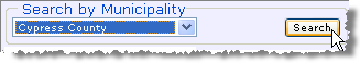
In this example, the municipal district of Cypress County is selected.
- Click Search next to the Search by Municipality field.
The map redraws to display the municipality plus a few of the surrounding parcels. The municipality is centred on the map and highlighted using red cross-hatching. When you change the current map view (by changing the scale, map centre, etc.), the red cross-hatching disappears.
If special spacing isn't visible at the current map scale, using the Zoom In tool () either drag a smaller area on the map, or click the centre of your area of interest.