- Using this screen
- Details of this screen
Using the Base of Groundwater Protection Query Tool
Using the Base of Groundwater Protection Query Tool
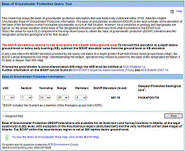
The Base of Groundwater Protection Query Tool. For details click on the Details tab.
BGWP elevations are available for all Dominion Land Survey (DLS) locations in Alberta, at the legal subdivision (LSD) level, with exception of the mountainous region (disturbed belt) and the most northeastern corner of Alberta. The BGWP within the mountainous region is set at 600 metres below ground level. A map depicting the BGWP default areas is available near the bottom of the Query Tool page.
To obtain the estimated BGWP elevation for a location:
- Select the value for the LSD, Section, Township, Range, and Meridian in the drop-down boxes and
- Click the Find button
If during drilling operations the BGWP formation is encountered at a different depth (as determined from subregional information, well logs, or other valid geological information) than what was identified in the BGWP tool, the actual BGWP must be defined as 15 vertical metres below the base of the designated protected geological unit at the well where drilling is being conducted.
If the difference is greater than 50 metres, the operator may proceed with their modified operations, and the AER requests that information related to the difference be forwarded to AGS-Info@aer.ca. If the difference is less than 50 metres, the operator may proceed without notifying the AER.
If nonsaline groundwater is encountered below 600 mbgl, the AER must be notified at AGS-Info@aer.ca
Further information on the BGWP can be found at AER BGWP Frequently Asked Questions (FAQs) and AER Bulletin 2007-10.