- Using this screen
- Details of this screen
Details of the Base of Groundwater Protection Query Tool
|
|
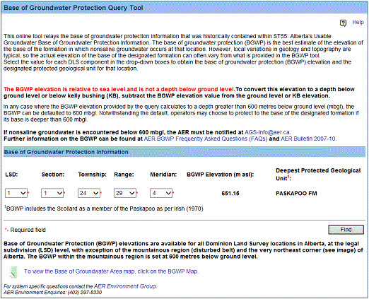
A sample of the Base of Groundwater Protection Query Tool. |
Screen Item Descriptions
Each item on this screen is listed and described below.
- LSD
- Click on the LSD drop-down list button and select the DLS legal subdivision of the location of interest within Alberta.
- Section
- Click on the Section drop-down list button and select the DLS section of the location of interest within Alberta.
- Township
- Click on the Township drop-down list button and select the DLS township of the location of interest within Alberta.
- Range
- Click on the Range drop-down list button and select the DLS range of the location of interest within Alberta.
- Meridian
- Click on the Meridian drop-down list button and select the DLS meridian of the location of interest within Alberta.
- Find button
- Click on the Find button to obtain the Base of Groundwater elevation and the name of the deepest protected geological unit.
- BGP Map link
- The BGP Map link, found on the lower left of the page, opens a PDF document that shows the township-range grids for Alberta and that highlights the disturbed belt and the excluded area in the northwest corner.